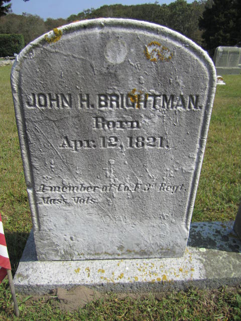
John H Brightman |
Lot Title
John Brightman 12 grave lot
Location in Cemetery
Section: G
Lot: 56
Grave: --
|
Date of deathFeb-21-1901 |
Date of birthApr-12-1821 |
Age0 yrs 0 mths 0 dys |
Verse (Legibility: G - GOOD)"A member of Co. F, 3d Regt. MA Vols." is engraved on John's stone below his name & DOB. |
Veteran Information
Veteran: Yes ")
|
RelativesJohn H. Brightman & his spouse Lucy Macomber are on separate marble tablets with a common granite base. |
Stone ShapeR - ROUNDED TOP |
Stone DecorationN - NONE |
Stone ConditionG - GOOD |
Stone MaterialM - MARBLE |
State of StoneU - OK - STANDING UPRIGHT |
Other InformationSon of Perry Brightman and Hannah Hazard. Married Lucy Macomber, daughter of Simeon Macomber and Abigail, August 24, 1845. After Lucy's death in 1851, he married Rachel P. Luther. John was a mechanic, a ship carpenter, and later a fisherman. John lived at 2044-46 Main Road. DOB given is 4/12/1821; DOD 2/25/1901 at age 80. A Grand Army of the Republic veteran's marker (#361) is next to his stone.
Source: Andrew C. Macomber and Richard W.Wertz. "Westporters and the Civil War.", typed and printed manuscript.
According to "MA Soldiers, Sailors, & Marines in the Civil War", he enlisted in Co. F., MA 3d Infantry Regt. & mustered out 26 Jun 1863 at Camp Hooker. |
|
|
Allen, Albert Julian
Allen, Almira Wilbor
Allen, Asa Bodfish
Allen, Bertha L
Clara E Lawton Allen
Allen, Cora B
Allen, Cornelius T
Allen, Eli Green
Allen, Eli Green
Elizabeth Tripp Brightman Allen
Emma L Manchester Allen
Allen, Georgiana S
Allen, Gideon
Julia A P Brightman Allen
Allen, Lizzie C
Allen, Mary Dunham
Allen, Pardon
Allen, Pardon S
Allen, Rebecca
Allen, William R
Allen, William
Allen, William M
Baker, Abbie
Abbie L Gifford Baker
Baker, Jehiel
Captain John H Baker
Baker, Mary W
Baker, Mercy Etta
Baker, Ursula
Ball, Aberdeen
Ball, Amy Davis
Ball, Captain Charles
Lydia A Davis Ball
Ball, Maria Amelia
Ball, Pardon K
Ball, Ruth Wilcox
Ball, Susan R
Barker, Hannah M
Barker, Mary W
Barnett, Betsy Mayhew
Bassett, Hannah Gifford
Bassett, Joseph S
Bateman, William Pitt
Bateman, William Hector
Beard, Elizabeth G
Beard, Samuel C
Bonney, America
Boyce, Anna
Boyce, Bertha H
Boyce, Caroline H
Captain Edward M Boyce
Boyce, Hannah A
Boyce, Hope E
Boyce, Stacy
Bradley, G E
Bradly, Emily L
Briggs, Charles Herbert
Mary S Tripp Briggs
Mary S Tripp Briggs
Briggs, Phebe Jane
Brightman, Alexander S
Brightman, Ann J
Brightman, Anna K
Brightman, Arthur B
Brightman, Betsey
Cordelia A Palmer Brightman
Brightman, Deborah
Brightman, Diana Dorothy
Brightman, Dianah A
Brightman, Dorethy A
Brightman, Edna M
Brightman, Elias P
Brightman, Emma
Brightman, Fulton P
Brightman, George T
Brightman, George L
Brightman, George W
Brightman, Georgie Lewis
Brightman, Hannah C
Brightman, Ida M
Brightman, Isaac L
Brightman, Isaac
Brightman, Israel A
Brightman, Jane W
Brightman, Captain Jeremiah
Brightman, John H
Brightman, Julia A
Brightman, Laura L
Lena W Briggs Brightman
Brightman, Linda C
Brightman, Lucy
Brightman, Lucy B
Brightman, Marietta
Mary E Manchester Brightman
Brightman, Nancy S
Captain Perry P Brightman
Phebe A Hart Brightman
Brightman, Phebe B
Brightman, Philenia Wood
Brightman, Rachel P
Brightman, Rebecca Churchill
Brightman, Restcome S
Brightman, Rodolphius A
Brightman, Rufus W
Brightman, Captain Samuel
Brightman, Samuel C
Brightman, Sarah B
Brightman, Sarah S
Brightman, Simeon M
Brightman, Thomas J
Brightman, Captain William
Brightman, William W
Brown, Charlotte
Brown, Elizabeth Seabury
Brown, Emeline
Brown, Henry A
Mary E Hicks Brown
Brownell, Cynthia B
Brownell, George C
Brownell, Horatio H
Cadman, Amy
Cadman, Hannah
Cadman, Ruth
Capen, Andrew Jackson
Capen, Kate Clark
Carroll, Selima
Alvira H 'Olie' Carter
Carter, Lemira W
Carter, Richard W
Case, Fally
Case, Leander
Case, Pardon
Chace, Anna M
Chandler, Lois K
Clark, John A
Mary A Baker Clark
Columbia, Infant
Connor, Charles M
Connor, Grace S
Cornell, James P
Cory, Albert F
Cory, Alexander H
Cory, Alexander H
Cory, Amy
Cory, Andrew
Cory, Charles B
Cory, Clarisa M
Cory, Deborah
Cory, Deborah
Cory, Diana
Cory, Drusilla
Cory, Elizabeth Bly
Cory, Emma Brownell
Cory, Hannah H
Cory, Helen C
Cory, Infant
Cory, Isaac
Cory, Captain Isaac
Cory, Isaac
Cory, Joseph P
Cory, Joseph A
Cory, Mary Cadman
Cory, Mary Brownell
Mary Ann Prince Cory
Cory, Mercy Brownell
Cory, Ruth
Sarah W Hammond Crandall
Cunningham, Cynthia B
Cunningham, Frederick M
Davis, Abby Sowle
Captain Alfred C Davis
Davis, Christopher A
Emma L Pierce Davis
Davis, Ezra W
Davis, Florena M
Captain Gideon Davis Jr
Davis, Gideon
Davis, Hannah P
Davis, Helen E
Davis, Huldah K
Davis, Infant
Davis, Infant
Davis, Isabel L
Davis, Isabel A
Davis, Isabel
Davis, Captain Job
Davis, John A
Davis, Julia A
Davis, Lucia A
Davis, Mary A
Mary Almy Allen Davis
Davis, Pardon
Sarah B Watkins Davis
Davis?, Infants Brightman?
Lydia A Macomber Dennis
Devoll, Benjamin
Devoll, Benjamin P
Mary A Wing Devoll
Devoll, Susan S
Durfee, Almira Mayhew
Durfee, Thomas
Dyer, Abraham
Dyer, Angeline
Dyer, Canaan G
Dyer, Charlie T
Dyer, Cynthia
Dyer, Ellen C
Dyer, Henry C
Dyer, Isaac T
Dyer, Lydia
Dyer, Samuel
Dyer, William
Gammons, Frederick A
Gammons, Hannah M
Rev. John G Gammons
Gammons, Merrill White
Gammons, Velzora Briggs
Gifford, Albert A
Gifford, Alida A
Gifford, Allen
Gifford, Ann Sisson
Gifford, Captain Benjamin
Gifford, Charles H
Gifford, Christopher
Gifford, Christopher D
Gifford, Christopher
Gifford, Cornelius
Gifford, Deborah
Gifford, Delilah
Gifford, Elizabeth
Gifford, Emeline
Gifford, George A
Captain George Gifford Jr
Gifford, Hannah R
Gifford, Hannah
Gifford, Hattie M
Captain Humphrey Almy Gifford
Gifford, Ina May
Gifford, Ina May
Gifford, James B
Gifford, Joseph A
Gifford, Julia A
Gifford, Lafayette L
Gifford, Lucy A
Gifford, Ludevena A
Gifford, Myra B
Gifford, Nancy
Gifford, Pardon
Gifford, Phebe Davis
Gifford, Russell
Gifford, Sadie B
Gifford, Samuel
Gifford, Sarah P
William H H Gifford
Lois Elaine Connor Goulart
Goulart, Manuel Louis
Grinnell, Deborah Brownell
Deborah A Palmer Grinnell
Grinnell, Kate L
Grinnell, Oliver Charles
Grinnell, Philip
Grinnell, Philip L
Grinnell, Thomas Palmer
Grinnell, Thomas P
Groves, Alexander
Groves, Lydia H
Hall, Anna Loraine
Hall, Basil Douglas
Hall, Charles Cuthbert
Hall, Jeanie Stewart
Hall, Katherine Stanley
Hall, Robert Andrew
Hall, Theodore Eldridge
Hammond, Caroline M
Charles W C Hammond
Hammond, Elijah R
Hammond, Emeline H
Lulu M Earle Hammond
Sarah E J Palmer Hammond
Hammond, William A
Hammond, William S
Hicks, Caroline A
Elizabeth P Howland Hicks
Hicks, William B
Hitt, Howard F
Hitt, Lizzie Leonara
Hitt, Mary Macgreevey
Hobbs, Adelaide T
Hogle, Amy Cadman
Hopkins, Susan M
Ann M Dyer Howland
Howland, Cippie D
Edna C Haskell Howland
Howland, Edward A
Howland, Eleanor C
Howland, Elma
Howland, Hannah M
Howland, Captain Jethro
Peace M Potter Howland
Howland, Rebecca
Howland, Rebecca
Howland, William P
Howland, William J
Howland, Willie
Howland, Zoeth
Hoxie, Polly
King, Alfred
King, Nancy M
Kirby, Cynthia
Kirby, Lydia
Kirby, Pardon
Bertha B Cory Kugler
Kugler, Jeanne E
Kugler, Louise Austin
Kugler, Richard C
Kugler, William A
Kugler, William E
Infant D W M
MacDonald, Mary Elizabeth
MacDonald, Theodore Ralph
Macomber, Abial
Macomber, Abigail H
Adin H N Macomber
Macomber, Alice
Macomber, Andrew H
Macomber, Andrew P
Macomber, Charles
Macomber, Charles F
Macomber, Charles
Macomber, Charlotte M
Macomber, Clara A
Macomber, Clarence Irving
Macomber, Deborah A
Macomber, Elihu G
Macomber, Eliza A
Macomber, Elizabeth
Captain Frank C Macomber
Macomber, Franklin E
Macomber, Franklin G
Macomber, George R
Macomber, George P
Macomber, George B
Macomber, George P
Isabel D Ball Macomber
Macomber, Israel
Macomber, Leon Sherwood
Macomber, Louisa D
Macomber, Lydia
Macomber, Mary L
Macomber, Mary S
Macomber, Mary Ann
Macomber, Mary L
Macomber, Mary E
Mary E Manchester Macomber
Macomber, Otis
Macomber, Pamelia
Macomber, Pardon A
Macomber, Pardon
Macomber, Captain Pardon
Macomber, Peace
Macomber, Permilla
Macomber, Phebe
Macomber, Priscilla B
Macomber, Rachel Brightman
Macomber, Restcome
Macomber, Rufus B
Macomber, Sarah
Macomber, Simeon
Macomber, Simeon
Macomber, Varnum
Macomber, William
Macomber, William R
Manchester, Abby
Angeline B Hart Manchester
Manchester, Aroet R
Manchester, Carrie A
Manchester, Charlotte S
Emily J Sowle Manchester
Manchester, George Woodworth
George L Manchester Jr
Captain George L Manchester
Manchester, Henry Eames
Manchester, Hercules
Manchester, James W
Manchester, James W
Manchester, James P
Lena E Evans Manchester
Manchester, Mary
Manchester, Pardon H
Manchester, Sarah E
Manchester, Theodore T
Manchester, William W
Manchester, William H
Mason, Mary Macomber
Mayhew, Almira D
Mayhew, Benjamin T
Mayhew, Benjamin T
Mayhew, Betsey Tripp
Mayhew, Charles M
Mayhew, Christopher Bly
Mayhew, Dorothy B
Mayhew, Eddie
Captain Edwin L Mayhew
Mayhew, Edwin L
Mayhew, Eleanor S
Mayhew, Hannah G
Mayhew, Captain Hillyard
Mayhew, Isabel B
Mayhew, Jeremiah B
Mayhew, Judith Brownell
Lydia T Wing Mayhew
Mayhew, Nancy
Mayhew, Oliver Hicks
Rebecca A Alty Mayhew
Mayhew, Ruth White
Mayhew, Thomas H
Captain Thomas W Mayhew
Medeiros, Sylvia Ann
Montigny, Howard R
Murphy, Clara B
Palmer, David C
Etta J Allen Palmer
Palmer, Falley
Palmer, Frederick W
Palmer, Hazel Tripp
Palmer, Henry
Louisa R Hammond Palmer
Melanie J Vohnoutka Palmer
Palmer, Raymond C
Palmer, Rose
Pettey, Alice M
Pettey, Emily R
Pettey, Lillian
William E L Pettey
Pineau, Alfred E
Pineau, Marion B
Porter, Charlotte B
Porter, Helen Irene
Porter, John B
Porter, Lottie
Potter, George H
Potter, Linwood S
Potter, Susan M
Preston, John Linnartz
Katherine Hamlin Hall Preston
Prince, Henrietta Scarborough
Scribner, Almeda
Scribner, Merritt
Sisson, Abbie C
Abby W. Gifford Sisson
Sisson, Abner
Sisson, Almy Gifford
Sisson, Caroline E
Sisson, Charles H
Sisson, Cynthia Ann
Sisson, Edith
Eliza A Potter Sisson
Sisson, George M
Sisson, George F
Sisson, George H
Sisson, Infant
Sisson, Jonathan F
Sisson, Susan Matthews
William F M Sisson
Snow, Lillian A
Soule, Adeline E
Sowle, Abel
Sowle, Alexander H.
Sowle, Andrew Hicks
Sowle, Andrew
Sowle, Charles P
Sowle, Charles T
Sowle, Clementine F
Captain Edward G Sowle
Sowle, Edward H
Sowle, Eleanor C
Sowle, Elijah H
Captain Gideon W Sowle
Sowle, Hannah H
Sowle, Israel
Captain James M Sowle
James M Sowle Jr
Sowle, James E
Sowle, Captain John
Sowle, Joseph H
Sowle, Mary F
Sowle, Mary Hannah
Sowle, Mary Sophia
Mary A Manchester Sowle
Sowle, Nancy H
Sowle, Oliver
Sowle, Patience H
Sowle, Phebe M
Sowle, Phebe A
Sowle, Philip Grinnell
Sowle, Polly
Sowle, Ruth A
Sowle, Ruth A
Sowle, Sophia
Sowle, Sophia
Sowle, William Marvel
Stevens, Alice C
Stevens, Ida May
Stevens, Infant
Stevens, John Warren
Stevens, John Warren?
Stevens, Leland Roswell
Minnie Frances Rose Stevens
Stevens, Susan Minola
Stoddard, Abbie M
Stoddard, Justin Jacob
Terry, Adeline S
Abby D Allen Tompkins
Tompkins, Clara L
Tompkins, Eddie L
Tompkins, Isaac B
Tompkins, Meribah
Tompkins, Captain Perce
Tompkins, Tilly B
Tripp, Albert Edward
Tripp, Alfred Clark
Tripp, Captain Allen
Tripp, Betsy A
Tripp, Clark Howland
Tripp, Eliza R
Tripp, Elizabeth
Tripp, Emma Adeline
Hannah C Wing Tripp
Tripp, Hervy Weston
Tripp, Job
Tripp, Lucy W
Lydia Davis Hart Tripp
Tripp, Mary Southern
Tripp, Mary Macomber
Tripp, Mary Southern
Mary A Freeborn Tripp
Tripp, Pardon A
Tripp, Uriah Howland
Tripp, William R
Washburn, George Edward
Watkins, Abigail Seabury
Watkins, Abigail
Watkins, Mary Davis
Watkins, Thomas
Watkins, William
Carrie B Brownell Wells
Dr W Scott Wells
West, Andrew D
West, Joanna I
White, Christopher
Wicks, Barbara Bruce
Wicks, Caroline Louise
Wicks, David Douglas
Wicks, Eleanor Macmaster
Wicks, Mary Boyd
Wicks, Robert Russell
Wicks, Robert Stewart
Williams, Betsey Dorsey
Wing, Abby A
Wing, Abby Gifford
Wing, Barney
Wing, Carlton B
Wing, Charles T
Wing, Edith A
Wing, Eliza
Wing, Eliza
Captain Frederick A Wing
Wing, Israel
Wing, Julia
Nancy S Brightman Wing
Captain Perry G Wing
Wing, Rachael
Wing, Stephen A
Susan P Allen Wing
Withee, Frances S
Wood, Bathana B
Wood, Israel
Wood, Rachel M
Woodward, Henry Stimson
Woodward, Philip Grinnell
Woodward, Ruth Margaret
Ruth Ellen Sowle Woodward
Woodward, Solomon
Woodworth, Charles W
Woodworth, Cynthia P
|